
1991–2019 · Community & course
1991–2019: Small Revisions, a Sale and the Plats Today
A pool association, a long run of small plat revisions, the 2014 sale and the 2019 waiver, and a map of the plat sections laid over today's aerial photograph.
Timeline
Feb. 8, 1990
Revision of Lot 12, Section 3 (Map Book U, Page 190).[Map]
Mar. 11 and 21, 1991
Brierwood Pool Association, Inc. files its articles with the state and they are recorded (Book 12, Page 854).[Articles]
Oct. 16, 1991
Revision of lots in Sections E and G (Map Book W, Page 22).[Map]
1992 and 1993
Single-lot and small-tract maps (Map Book X, Pages 41 and 118; Map Book Y, Page 40).
Jan. 1, 1994
The Declaration's first 25-year term ends.
1995 and 1996
Section 3 lots revised (Map Book Z, Pages 372 and 373); tracts (Map Book 17, Page 66); Section C lots (Map Book 17, Page 295).[Section 3 · Section C]
Nov. 16, 2001
Lots 1 to 9 of Section O and two tracts (Map Book 25, Pages 143 and 144).[Map]
July 17, 2014
The golf course, clubhouse and some lots are sold to Blum Investment Group Golf LLC (community history).
Oct. 17, 2014
Waiver of first right of refusal for Lot 5, Section 3 (Book 3577, Page 233); no copy is kept on this website yet.
June 1, 2017
The golf course closes.
June 19, 2019
Blanket waiver of the right of first purchase for the whole subdivision (Book 4206, Page 892).[Waiver]
Document links open for registered members who are signed in. The plat images on this page are public records shown for everyone.
On March 21, 1991 the articles of incorporation of Brierwood Pool Association, Inc., filed with the North Carolina Secretary of State on March 11, were recorded in Book 12, Page 854. The association was formed to own and operate a private membership swimming pool in Brierwood Estates.
From 1990 on, the plat records are a long run of small adjustments. A revision of Lot 12 in Section 3 (Map Book U, Page 190, February 8, 1990); lots in Sections E and G (Map Book W, Page 22, October 16, 1991); single lots and small tracts in 1992 and 1993; lots in Section 3 again in 1995 (Map Book Z, Pages 372 and 373); and Section C lots in 1996 (Map Book 17, Page 295). Each is a lot line moved, two lots combined or a tract carved out. None replaces the 1973 plat; each points back to it.
On January 1, 1994 the Declaration's 25-year first term ended and the covenants began renewing in ten-year periods. In the same decades the right of first purchase was released lot by lot at each sale, a routine that ended with the blanket waiver of June 19, 2019 (Book 4206, Page 892).
The community's history says the golf course, clubhouse and assorted residential lots were sold on July 17, 2014 to Blum Investment Group Golf LLC; the course closed on June 1, 2017. In between, from October 2014, the developer's successor recorded waivers for individual lots, for example a waiver for Lot 5, Section 3 recorded October 17, 2014 (Book 3577, Page 233). See The Ward Family Sells and The Last Round.
County parcel data lets the plat sections be laid over a current aerial photograph. In the map below, every parcel the county describes as Brierwood is colored by the section named in its legal description and labeled with the year of the plat that created or last revised it: Section 2 (1969), Section 1 (1972), most of the lettered sections and Sections 3, 4 and 9 (1973), and Sections J, K, L and N (1973, revised 1985). The grey areas are the golf course and other tracts.
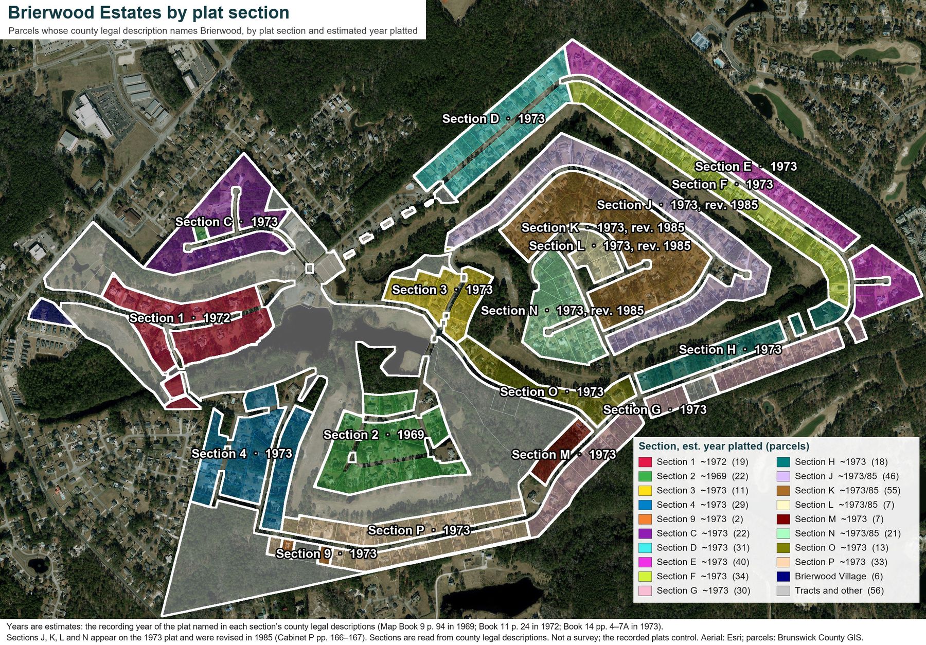
That map is the series in one picture. The Queens Grant lots of 1969 and the Brierwood Road lots of 1972 are the oldest; the 1973 plat covers most of the rest; and the revisions of the 1980s and 1990s sit inside those boundaries. The sections are read from county legal descriptions, so a lot recorded without a section letter appears as a tract. The recorded plats control. The plat-style sheet that follows draws the same sections the way a recorded plat would, with a labeled block and arrow for each.
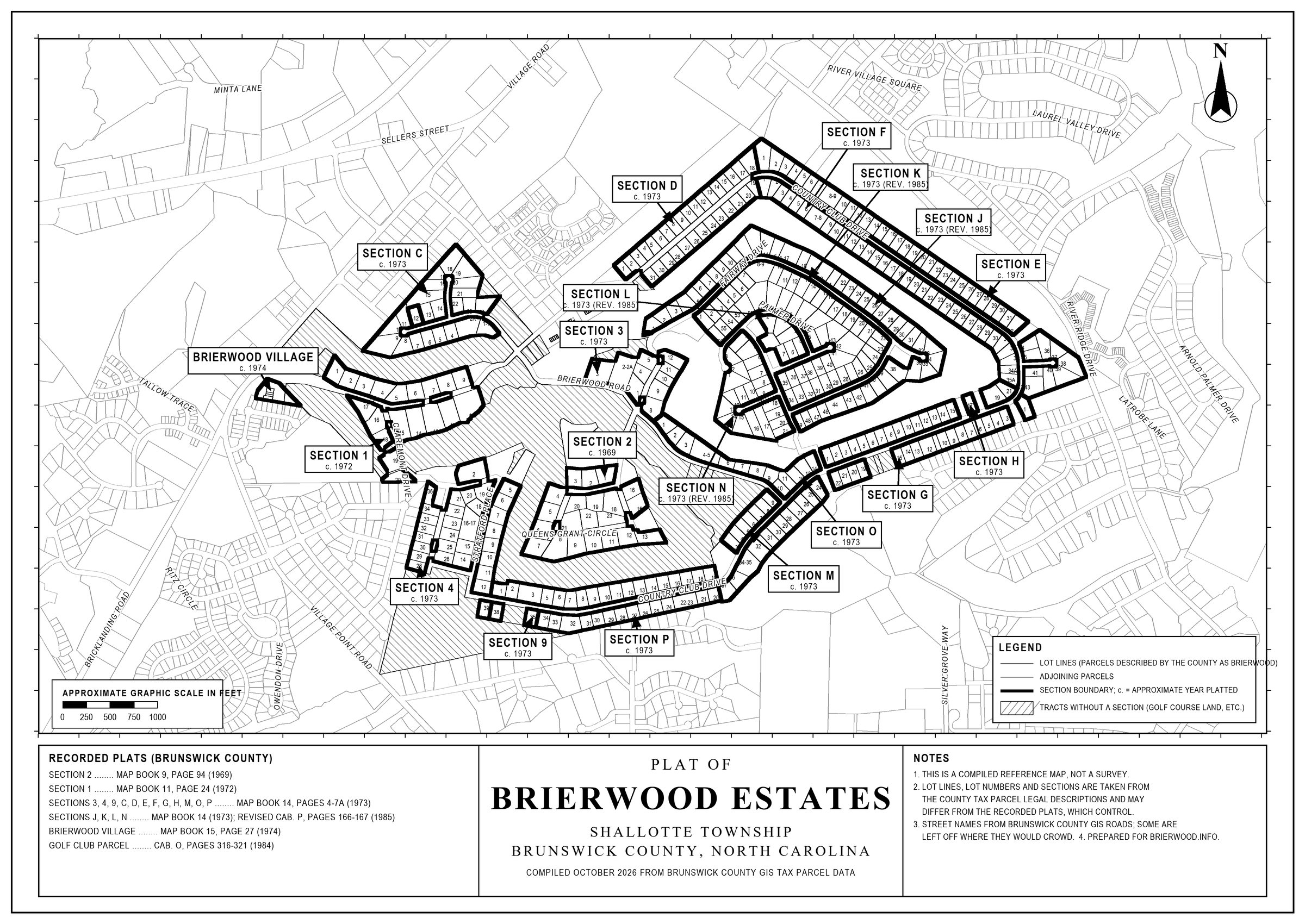
For every recording behind the series, with links to the downloaded documents, see the Documents Index. For the Declaration's rules, see the summary on the Documents page. For where things stand with the golf course property, see Brierwood Estates Today and Tomorrow.